


Center Precinct 2, Stevens County, Kansas
About
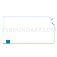
Outline

Summary
| Unique Area Identifier | 587474 |
| Name | Center Precinct 2 |
| County | Stevens County |
| State | Kansas |
| Area (square miles) | 101.73 |
| Land Area (square miles) | 101.71 |
| Water Area (square miles) | 0.02 |
| % of Land Area | 99.98 |
| % of Water Area | 0.02 |
| Latitude of the Internal Point | 37.17736650 |
| Longtitude of the Internal Point | -101.22136880 |
Maps


Graphs
Select a template below for downloading or customizing gragh for Center Precinct 2, Stevens County, Kansas


Neighbors
Neighoring Voting District (by Name) Neighboring Voting District on the Map
- Banner Township Voting District, Stevens County, KS
- Center Precinct 1, Stevens County, KS
- Harmony Township Voting District, Stevens County, KS
- Hugoton Ward 1 Precinct 2, Stevens County, KS
- Hugoton Ward 2 Precinct 1, Stevens County, KS
- Hugoton Ward 2 Precinct 2, Stevens County, KS
- Liberal Township 1 Voting District, Seward County, KS
- Moscow Township Voting District, Stevens County, KS
- Voorhees Township Voting District, Stevens County, KS
- West Center Township Voting District, Stevens County, KS
Top 10 Neighboring County Subdivision (by Population) Neighboring County Subdivision on the Map
- Center township, Stevens County, KS (4,396)
- Moscow township, Stevens County, KS (687)
- Liberal township, Seward County, KS (548)
- Banner township, Stevens County, KS (192)
- Voorhees township, Stevens County, KS (191)
- West Center township, Stevens County, KS (142)
- Harmony township, Stevens County, KS (116)
Top 10 Neighboring Place (by Population) Neighboring Place on the Map
Top 10 Neighboring Unified School District (by Population) Neighboring Unified School District on the Map
- Liberal Unified School District 480, KS (21,038)
- Hugoton Public Schools Unified School District 210, KS (5,050)
- Moscow Public Schools Unified School District 209, KS (740)
Top 10 Neighboring State Legislative District Lower Chamber (by Population) Neighboring State Legislative District Lower Chamber on the Map
Top 10 Neighboring State Legislative District Upper Chamber (by Population) Neighboring State Legislative District Upper Chamber on the Map
Top 10 Neighboring 111th Congressional District (by Population) Neighboring 111th Congressional District on the Map
Top 10 Neighboring Census Tract (by Population) Neighboring Census Tract on the Map
- Census Tract 9652, Stevens County, KS (4,110)
- Census Tract 9656, Seward County, KS (2,397)
- Census Tract 9651, Stevens County, KS (1,614)